Where was the Three Gabled House?
Where in Leigh was Charles Septimus Clarke’s famous three gabled house located? This is the story of my experience of gathering evidence and assembling the puzzle pieces that allowed us to solve this genealogical question.
Note: this is a revision of a post originally written in August 2014.
Charles Septimus Clarke was my great-great grandfather. He was born in Leicester in 1843, the youngest son of an affluent family of the “landed gentry” class. He immigrated alone to New Zealand in 1863, arriving on his 20th birthday. On the journey he befriended the Wyatt family (who settled in the same area and whose daughter Mary Anne became my great-great grandmother). He took a crown land grant at Leigh (then called Little Omaha), north of Warkworth. Later he bought a farm in the area and built a three gabled house, which became a well-known landmark – one of only 3 in the district “noted alike for hospitality as for their prominence and architecture.” (New Zealand Herald – February 1876). Except for a few years spent in Auckland, he lived in this house for 50 years. Unfortunately no trace of the original site of the house is left. He sold the property in 1920 to John Charles Edgar (Eddie) Wyatt. He boarded with Eddie and Ivy Wyatt in their cottage over the road until 1923 when he left Leigh to move a few kilometres down the road to his daughter’s house in Whangateau. In April 1924 the old house was dismantled and pulled down the hill, closer to the road, where it was rebuilt into a new house for Eddie and Ivy.
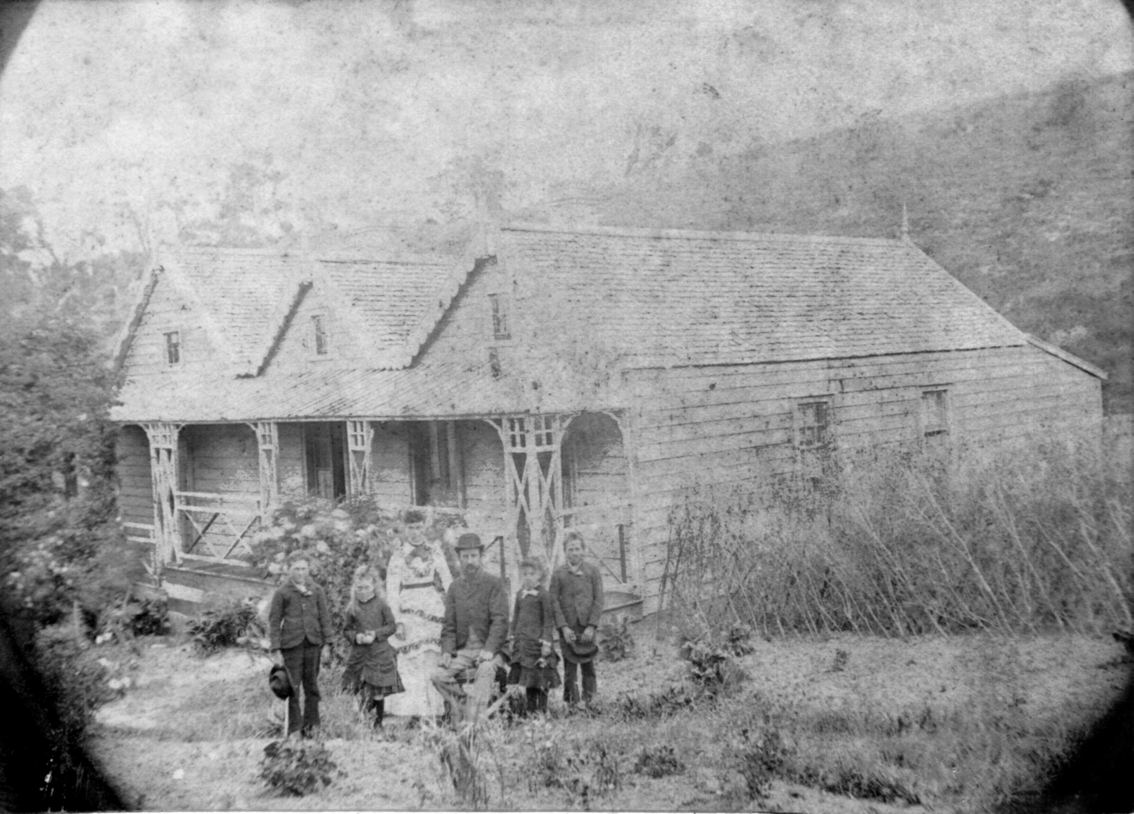
We have two photos of the house, one with the family posing at the front, which must have been taken around 1885-1890 (see main photo), and another of a back view, date unknown. Both these photos show faint outlines of the shape of the land on the horizon, which we though could aid us in pinpointing the position the photos were taken from.

My Uncle Alvin did extensive research into family history, and when he died my father took possession of all his papers and research notes. In these notes, on an annotation to the photo we have of the house Alvin has written: “The house was almost opposite the present Sawmill Cafe in Leigh, but about two hundred metres from the road. The site, which is beyond a slight ridge in a dip in the land, looks east towards the Leigh Hall, down the harbour and out to the Gulf. The site is still clearly marked. There’s a line of trees, and there’s an area of turf clearly different from the surrounding paddock.” The note is dated 2000, but unfortunately there is no record of the source of this information.
Charles Septimus Clarke himself wrote a large document detailing the history of the area, and in this he wrote:
“On 27 th April 1866 I purchased the 80 acre farm of Kenneth McKenzie (Red Kenneth) as a going concern for the sum of £240 cash.” and “In 1868 I purchased 3, 40 acre sections joining my first purchase for £120 cash, these sections belonged to Mrs Margaret Matheson, Miss Hannah Matheson and Neil Campbell. On Campbell’s section a small clearing had been made. And on this clearing I built a good sized house, the timber was pit sawn on the place.”
From Alvin’s papers we have a photocopy of a survey map of the area produced in 1887, on which we can pinpoint the position of the Sawmill Cafe on the Pakiri Rd (marked on the map above with a green dot). This road is marked on the map in a broken line with the words “Present Road In Use”. This map also shows the position of the school at that time.

In the local history booklet “Leigh, Then and Now”, some hints are given that CS Clarke gave some of his land for the school and the road. This is confirmed by an article located in Papers Past. From the New Zealand Herald, Volume IX, Issue 2489, 17 January 1872, Page 3
“Mr C.S. Clarke started that the trustees had requested him to call the meeting with a reference to opening a new line of road to the village of Leigh. The proposed new road would cross his property. He was willing to give the land on condition that the ratepayers secured to him another road that joined his property on the other side, but which was of no use to anyone, and could never be made a road, on account of the broken nature of the ground. The meeting accepted Mr. Clarke’s very kind offer, and appointed Messrs W. Greenwood, M. Kirkbride, and A. Matheson, a committee to open the new road, and secure the other to Mr. Clarke. A general conversation followed, on the old question of a school site, ending in a decision that a building was to be put up, the majority of the settlers having come to the determination to do without a building no longer. Accordingly a meeting was held on Wednesday evening, at the the residence of the Mssrs. Wyatt. Mr. M. Kirkbride as vote to the chair, Mr C.C. Clarke said he was willing to give half an acre of land, and would suggest that what was wanted was a building, not only for a school, but also for preaching, meetings, or amusements. The following resolutions were put to the meeting and carried:-1. That Mr C.S. Clarke’s offer be accepted; 2. That the building be constructed out of public subscriptions, &c.; 3. That a building committee of three be appointed, to consist of Messrs. Matheson, C.S. Clarke, and M. Kirkbride, to collect subscriptions &c., and report to subsequent meeting.”
From this information we deduced that CS Clarke owned lot EP27 (80 acres), NP26 (40 acres) MP26 (40 acres) and SP26 (40 acres). In the 1881 electoral roll for Rodney “Charles Septimus Clark” is listed, with notes “26; Omaha; October 1881″.
From the Archives NZ website we found the deeds register index entries for the “Parish of Omaha” No. 27, and middle, northern and southern parts of No. 26. These confirm that Clarke bought these four pieces of land in 1866 and 1867.
The exact position of his house on this block of land is more difficult to pinpoint. We can first narrow it down to “Campbell’s land”, which is the middle of No. 26. This agrees with Alvin’s information that the house was opposite the sawmill (see map). But it’s hard to know whether the description given by Alvin was his own conjecture or if this was definitive information he had obtained from a reliable source.
The booklet “Leigh, Then and Now”, gives a history of the Leigh Library (which was once housed inside CS Clarke’s house). “His house was built on the hill above Len Wyatt’s home…” Len Wyatt was John Leonard Wyatt, a well known Leigh identity who died in January 2015. He was a son of John Charles Edgar (Eddie) Wyatt, who was the nephew of Charles and Mary Ann Clarke. He lived on Pakiri Rd near the sawmill. However “on the hill” wasn’t a very useful clue to the exact position of the house.
In February 2015 Dad and I armed ourselves with the photo of the house and Alvin’s description of it, and arranged to meet Dad’s cousin Barry Torkington, who lives in Ti Point and purported to know the location of the house. We met at the Sawmill cafe and climbed the fence over the road to roam around the paddock. Barry didn’t seem to think this would be a problem for the present owners of the land. We started off along the fence line to the south of a large area of pine trees. Working off Alvin’s description we tried to find an “area of turf clearly different from the surround paddock”. However the whole area was covered with knee high grass and nothing could be distinguished as having been previously occupied. If this was indeed the site of the house the past one hundred years had done a good job of obliterating all previous signs of occupation! We couldn’t identify anything as “clearly marked”. We identified an area where the land slightly levelled out as a likely candidate and compared the contours of the land with what we could see in the two photos. We came up with several theories, but we couldn’t decide on anything definitive. We returned home with the belief that we may never know where the house had stood.
February 2017
Nearly two years after our first field trip we returned to the question of the site of the house when Dad found an old photograph of two women standing amongst some grass and trees (one of these women was probably Alma Smith, Dad’s mother). The caption on the back read “Site of CS Clarke’s House in Leigh June 1957”.

I posted this photo and the caption on the Leigh Historical Photos Facebook group (which contains a wealth of historical photos and knowledge of the area) hoping that someone might have some information about the house, or recognise the location in the photo. I almost immediately got a message from someone who claimed to know exactly where the house had been. His name was Tim and he explained he was the partner of the daughter of Peter Wyatt, the grandson of Eddie Wyatt (who bought the land from Clarke in 1920). He told us that Peter Wyatt now owns the land and lives in a house on the property. Through knowledge passed down through the family he could identify the exact spot where the house had been. He pinpointed the position on a satellite map of the property.

The position was in fact in quite a different place to our original theories, but fitted in much better with our increasing knowledge of the house. A few months later Dad happened to meet Peter Wyatt at a family funeral and had a good chat about the CS Clarke and the old house. Peter invited us to come up for a visit some time and view the site for ourselves.
May 2017
On Sunday 23rd April we made the trip up to Leigh to visit Peter Wyatt. Peter is a son of Norris Wyatt, Eddie Wyatt’s second son. Peter is my fourth cousin through the Wyatt line, although he is actually also my third cousin through the Matheson line (Dad’s maternal grandmother was a Matheson). Peter told us a bit of what he knows about the history of the house. He knew that after Clarke had sold the property and moved out it was pulled down from the hill and rebuilt into a house that Eddie and Ivy Wyatt lived in for many years. This house was similar in layout to the original house, though the three gabled roof was converted into a single A-line roof. He showed us where this house had stood, very near to his present house. Much of the old furniture had also been moved into this new house. The house remained there for many years but in 1993 (?) when Peter started building a new house on the property he pulled the house down as it was in a bad state of repair. He salvaged many of the old kauri timber planks which he used to make some beautiful furniture that is currently furnishing a little guest cottage on the property. He still has quite a number of the planks and he gave us a decent sized piece to take with us. Some of the original furniture may have been taken to the original Wyatt homestead on Mt Pleasant.
We hopped in his ute and started on the drive up to the site of the original house. We drove out onto Pakiri Rd and up the hill for a short way then through a farm gate and up a track on the property. This took us up a ridge where Peter pointed out the land that had been donated for the school house. We turned off the track and headed down through the paddock a short way and parked at the top of a small hill. From here Peter pointed out a line of tree stumps that had once been a macrocarpa hedge, and a few pear trees that had been part of an orchard. Running down the hill over a fence was a pine plantation with a ditch-like water course running through it. Peter said when he was younger he had known the location of a well in the pines, but it had been covered over when the trees had last been felled. He thought he remembered approximately where it had been but hadn’t been able to uncover it. He had used the location of the well to place the site of the house, as the photo of the back of the house showed a path with a bridge over the ditch/water course that probably led to the well.
We spent some time walking around the area and comparing the two photos we have of the house. We felt confident that this was the correct location as the terrain of the land seemed to match what we could see from the photographs, and with the few descriptions we had from the diaries. It was great to talk to someone who had first-hand family knowledge of the property. Peter offered to take us for a tour around the whole property one day during summer when the land was drier – an offer we will be very keen to take up!