Early settlers in The Suburbs of Leigh
Compiled by Jo Evans
from
NZ National Archives Crown Grant volumes
NZ National Archives Deeds indexes Vol 1B – 8B
https://journeys.falkor.gen.nz/ by Raewyn Hooper
Extracts of my Diaries by Charles Septimus Clarke
Personal communications with family descendants
Treaty of Waitangi historical reports
Pioneer land surveyors of NZ – NZ Institute of Surveyors
November 2021
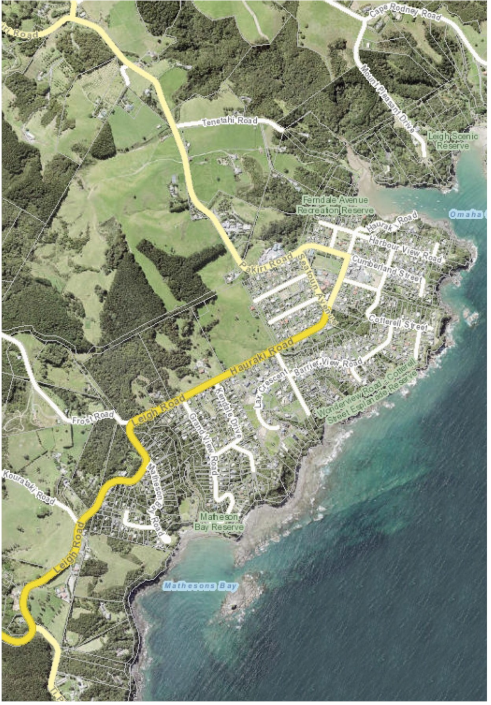
Compare this image and the next to relate it to the present day:
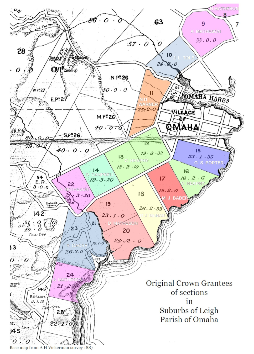
Sections in the Suburbs of Leigh
The original survey of the Omaha district divided the area into 3 categories:
- Village of Leigh, surrounding the harbour being mostly 1 acre sections.
- Suburbs of Leigh, further out being sections typically about 15 to 30 acres.
- Parish of Omaha, being rural blocks of 40 acres or more.
The Lot numbers for Suburbs and Parish share a common scheme, the Suburbs numbered from 1 to 25, Parish blocks from number 26 upward. This document is concerned with Suburbs of Leigh only.
CG = Crown Grant
- Lot 1-6: The Parish index shows these as ‘Omaha Block’. An 1885 survey map marks these as ‘NL’ which I presume is Native Land.
- Lot 7: The Parish index shows this and Lot 8 as ‘Pah/Omaha’.
- Lot 8: Purchased by Norman Matheson for £18, highest bidder at Supreme Court auction 22 April 1892, presumably sold on behalf of Maori owners. Norman was son of Angus Matheson10.
- Lot 9: CG to Angus Matheson10, 16 Sep 1867. To his wife Jessie on his death in 1887.
- Lot 10: CG to John Lambert Tole1, 2 July 1864. It was sold to Dunning in 1896, to Woodcock in 1924 then to Wyatt in 1936.
- Lot 11: CG to Nelson Horatio Warner, 22 Nov 1859
- Lot 12, 13, 16: CG to Charles Heaphy2, 22 Nov 1859. Lot 16 was sold to Alexander John Haskell4 in 1891 and Lots 12, 13 sold to Wyatt in 1898.
- Lot 14: CG to Donald Campbell3, 22 Nov 1859. Sold to Cyrus Haskell4, 23 Jan 1878. We don’t know if Donald was related to Neil Campbell3 who was granted the Middle portion of Lot 27 in 1864 which he sold to C S Clarke 3 years later.
- Lot 15: CG to George Samuel Porter5, 22 Nov 1859. Sold to Capt. Kenneth McKenzie, 29 Aug 1866. Changed hands many times over next 30 years or so.
- Lot 17: CG to Mary Jane Baber6 22 Nov 1859. Sold to Stewart (1860), Kirkbride (1864) who kept it for 12 years. Subsequently changed hands many times, various owners include Torkington, Gravatt, Whitaker.
- Lot 18: CG to Robert John McNab7, 22 Nov 1859. To Mrs J McNab (1872) , to Dunning (1881), Greenwood (1921).
- Lot 19,20: CG to Duncan Matheson8, 22 Nov 1859. Stayed in Matheson family until 1927 when passed to McCallum Bros.
- Lot 21, 23: CG to Ranulph Dacre9, 22 Nov 1859. Sold to Matheson (1885).
- Lot 22, 24: CG to Angus Matheson10, 22 Nov 1859. Passed to Jessie Matheson (1887).
- Lot 25: ?
Notes
-
John Lambert Tole came to New Zealand with his father John and other members of his family in 1854. John senior was a fully qualified surveyor and architect and commenced practice at Auckland. Four of his sons, John Lambert, William, Edward Francis and Daniel Austin entered the surveying profession while the youngest Joseph Augustus became a solicitor and later Minister of Justice. C S Clarke says some of the area was surveyed by a Mr Tole who purchased several blocks in the early 1860s. Lots 43-44 were granted to a Tole in 1861 and two years later Lots 60-63 similarly. In 1864 John Lambert Tole received Lot 10, adjacent to Lot 63 as a Crown Grant. Joseph Tole purchased Lot 87 on the hill off the road to Pakiri in 1864. Most of the Tole land came into the possession of Archibald Dunning in 1896.
-
Charles Heaphy arrived in NZ in 1839 aged 17 after 1½ years at the Royal Academy of Art, London to take up a position with the New Zealand Company as draughtsman and illustrator. He was Chief Draughtsman Auckland Survey Office from 1848. With his wife he moved to Warkworth in 1854 as district surveyor for the Mahurangi Peninsula. He served on the Government side in the land wars (1863-4) and awarded the VC for assisting the wounded under fire. Moving to Wellington when appointed ‘Chief Surveyor to the General Government of NZ’, he stayed there until early 1866 when he returned to the Auckland Survey Office. Heaphy died in 1881 a short time after moving to Brisbane.
-
We can’t be definitive about the Donald Campbell who was granted Lot 14 in 1859. There was a Donald Brackmuch Campbell who married Ann Matheson in Nova Scotia before emigrating to NZ. Ann had a sister, also called Ann(e), who married Cyrus Haskell in Auckland in 1859. Haskell purchased Lot14 from Campbell in 1878 so it is very likely that Campbell was his brother-in-law. We think it was he who was granted 180 acres at Waipu that same year. He died in Waipu in 1887.
His son Neil Matheson Campbell, who came out to NZ on the Spray, could well be the the Neil Campbell who was granted the middle portion of Lot 26 (adjacent to Lot 14) in 1864 because when C S Clarke wanted to purchase it in 1867 he dealt with Angus Matheson, Neil Matheson Campbell’s uncle. Campbell was absent in Picton at the time. Neil Matheson Campbell died at Waipu in 1913 so it is possible (though only speculation) that he had gone to Waipu to take up the 180 acre block when his father, Donald, died there.
-
Although Cyrus Haskell was born in 1816 at New Gloucester, Cumberland, Maine, United States of America his parents were British nationals and he proudly maintained he was a British subject ‘and never was a subject of any Foreign state or sovereign’ [Haskell’s Last Will and Testament]. We don’t know when he came to New Zealand but his first wife Anne Smith died in Auckland in 1850 leaving him with a two-year-old daughter, Martha Ann who died 9 years later. He got married again, in 1851, to Christiana Wynberg in Auckland but she died in January 1859 without bearing any children and he wasted no time in marrying again, in April of that year, to Anne Matheson. They lived, until at least 1862, at what is now the Auckland suburb of Henderson where Cyrus had worked in timber milling since 1854 and they had 3 children – Kitty Ann (1860), Mary Ann (1862) and Alexander John (1864). Anne, as Jessie Matheson’s sister, was Angus Matheson’s sister-in-law and cousin – they all come out to NZ from Nova Scotia in the ship Spray.
The family moved to start farming at Leigh in 1878 when Cyrus purchased the almost 20 acres of Lot 14 from Donald Campbell who we think was his wife’s brother-in-law. Campbell had been granted 180 acres at Waipu in 1866 and presumably decided to move north to develop a more viable farming operation on the much larger block of land. When Cyrus died in 1885 his son Alex carried on farming their small block supporting his mother and sister Mary Ann. We don’t know what happened to the other sister Kitty Ann but Matheson family lore says there was a child who died young. Charles S Clarke, whose farm bordered the Haskell’s and who mentions them often in his diaries (frequently mending the fence after recovering his cattle that had strayed on to their land), never mentions Kitty. Mary Ann married her cousin, Angus Matheson’s son Alexander, in 1893 raising 7 children on their farm above Goat Island.
Alex Haskell purchased Lot 16 from Heaphy in 1891 but disposed of it 10 years later. He married Eva Sullivan in 1896. After his mother died in 1901 he stayed on at Leigh until 1923 when he sold Lot 14 and moved to West Auckland with his son James, dying there in 1939.
-
In his Extracts of my Diaries C S Clarke says George Porter ‘was a compositor by profession and several times went to Auckland to work on the Auckland newspapers to provide necessaries for the family, he was the first one to plant an orchard or make a flower garden, he also introduced water cress into the creeks. The family left the district in 1866 having sold the place to Capt McKenzie his next neighbour for £70.’
Clarke frequently mentions visiting Mrs Porter to deliver or collect his laundry and sometimes she brought it to him, presumably at his Speedwell property on the north side of Little Omaha. His last diary entries that mention the Porter family are from the first week of September 1866 when he purchased 4 beehives from the Porters and the next day Mrs Porter’s ‘things’ were taken down to the beach in the slay [?sleigh] – presumably she was leaving the property the Porters had sold to Capt. McKenzie on 29th August and she was waiting for the boat to take her (? and children) away.
-
James Baber was a trained surveyor, architect and engineer who came to NZ in 1842 and was very active surveying around the greater Auckland region. C S Clarke says ‘The first survey of land for the settlement was made by Messrs Heaphy & Baber in or about the year 1858’. Lot 17 is adjacent to Heaphy’s Lot 16. The grantee Mary Jane Baber is described in the title deed as spinster of Remuera so she is either his sister or daughter. James is a signed witness of the deed of sale to Angus Stewart in 1860.
-
Robert John McNab came out to NZ on the Spray with his wife Jessie, the sister of Duncan and Angus Matheson8,10. As well as Lot 18 in the suburbs he was also granted Lot 56 in the Parish of Omaha being 40 acres near Cape Rodney. Robert died in 1861 and 10 years later Jessie married Horace Frederick Sealy, 12 years her junior. In 1872 Jessie became the legal owner of both lots when Robert’s father, Dugald Buchanan McNab of Sydney, Cape Breton, Nova Scotia, Canada, and heir to Robert’s estate relinquished his ownership, conveying them to Jessie “for the natural love and affection I bear to [her and] in consideration of five shillings sterling”.
Horace and Jessie opened the Sea View Hotel at Leigh in July 1878 and ran it for three years hosting a dinner and dance after the Omaha Agricultural and Horticultural Show of March 1879. In June 1881 they transferred the lease to Enock Bond, sold Lot 18 to Dunning and moved back to Auckland where Sealy worked as a tailor. They lived first in Beresford St (probably in a house belonging to Sealy’s father, a well known watchmaker in the city, which burnt down in a major fire in the Upper Queen St area in 1893) and later in Wellesley St. About 1890 they moved again, this time to Whangarei where Sealy set up a tailors shop in the main street and dabbled in silver mining in Puhipuhi. He appears to have associated with the town’s high society being an invited guest at the Northern Club Ball of 1891 in honour of the Governor and the Countess of Onslow (Jessie was not invited) and it was while out sailing on Whangarei Harbour on Sunday 2 Oct 1892 that he and 7 of his companions were drowned.
Jessie moved back to Auckland living in Edwin St, Newton. Early in 1894, she sold Lot 56 to her nephew Duncan Alexander Matheson who was farming his deceased father’s (Angus) land along the coast to Goat Island. Tragically, two months later she died in hospital – according to the inquest from ‘the effects of drink and exposure’ – having been found unconscious outside her house the previous morning. But she was by no means destitute having £157 18s 1d in her Post Office savings book and it was believed she owned the house in Edwin St.
-
Capt Duncan Matheson and his brother Capt Angus arrived in NZ on the Spray in 1857. Within two years they had both settled at Matheson Bay and had begun ship building on the beach. Duncan had married his first cousin Catherine Finlayson soon after arriving in New Zealand and he built a house, which is still there today, on Lot 20 on a promontory just above the eastern end of the beach. The brothers completed the schooner Saucy Lass in 1864 and Duncan built 3 more schooners, Coquette, Ryno and Three Cheers. Tragically he was killed while rigging the last in an Auckland shipyard in 1882 leaving his widow with four children. He was staying with C S Clarke and family in Auckland at the time of his death.
In 1864 Duncan had been granted Lot 55 Parish of Omaha near Cape Rodney and adjacent to his brother Angus’ blocks along the coast to Goat I.
-
Capt Ranulph Dacre was a colourful and enterprising trader, adventurer, and pioneer of the timber export trade in NZ. In 1816 at the age of 19 he retired as midshipman from the Royal Navy to command a schooner trading to the West Indies, Australia and the Pacific Islands. From 1827 he began making frequent voyages to New Zealand for sawn timber and spars for the British navy. About 1830 he settled in New South Wales and married. While trading around the NZ coasts Dacre negotiated directly with Maori for timber rights and land purchases from Mongonui to Coromandel including the Mahurangi area. He brought his family to settle in Auckland in 1859 where he became a well respected city father. Dacre and his wife left NZ in 1878, and he died in England in 1884.
C S Clarke says Dacre purchased 2,000 acres from Maori at Whangateau in the early 1860s although this date does not seem to be correct (see note 11 below). This large block, that became known as Dacre’s Claim, stretched from Kohuroa Creek (Matheson Bay) in the east to around about Omaha Valley Rd in the west, and from the ridge (today’s Rodney Rd) in the north to the Whangateau Harbour. It included some Ti Point land. But Clarke says “after a while the Maoris disputed Dacre’s right to the land” driving off the lessee who was removing the timber and they (Maori) began to sell portions of it. Later, he says, in 1886 the Government surveyed the whole area into 50 acre sections.
Just whether or how Lots 21, 23 relate to Dacre’s Claim is problematic. Being west of Kohuroa Creek they should, according to Clarke’s description, be part of Dacre’s Claim. But the fact that they were recorded as Crown Grants in 1859 suggests they were not.
-
Capt Angus Matheson built sailing vessels with his brother Capt Duncan Matheson on the beach at Matheson Bay (see note 8 above). He commanded several vessels trading around NZ and built the cutter Rangatira for Tenetahi in 1876.
Angus had married his first cousin Jessie Matheson – not to be confused with his sister Jessie who had married Robert John McNab (see note 7 above) – before emigrating to NZ. The brothers built houses on low promontories at opposite ends of Matheson Bay. Angus and Jessie’s two storied house was at the western end of the beach at the NE corner of his Lot 24 and close to the boundary with Dacre’s Lot 23. It is near a memorial plaque celebrating the arrival of the Scottish families from Nova Scotia on the Spray in 1857.
Angus also obtained three blocks of rural land in 1864 and 1867 along the coast from Goat Island to Cape Rodney as crown grants although one of the blocks (Lot 57) was granted in the name of Isabella Matheson, possibly Angus’ daughter.
Angus died at home in Matheson Bay in 1887 and after Jessie died in 1900 the house became derelict. Later the upper floor was lowered to convert it into a single story. This was probably after about 1920 as there is a very early aerial photograph of Ti Point and Whangateau showing the house clearly in its two storied form. This photo was most likely taken from the pioneer air mail plane which passed over this area daily on its route from Auckland to Whangarei during 1921. Then in 1926 the house was dismantled into slabs and floated as a raft around to Goat Island Bay where it was re-erected near the cliff overlooking the beach – approximately where the Marine Reserve upper car park is now.
-
Dacre’s Claim. According to Ranulph Dacre’s obituary in the NZ Herald (11 Oct 1884), and repeated in a number of commentaries about him, he purchased 4000 acres at Omaha. This is not correct.
The European ownership of this block of land goes back to pre Treaty of Waitangi times. A Historical Report commissioned by the Waitangi Tribunal by Barry Rigby in August 1998 (The Crown, Maori and Mahurangi 1840-1881) details that William Webster negotiated with Hauraki people a 10,000 acre ‘Point Rodney’ claim in 1839. But after 1840 the Crown did not recognise so-called ‘Old Land Claims’ and in 1841 the crown purchased from Maori a large area called the Mahurangi Purchase stretching from Takapuna to Te Arai. Presumably to compensate Webster it granted him in 1844 a more-or-less rectangular portion of 1,944 (cf. Clarke’s 2,000) acres surrounding Whangateau Harbour. Webster subsequently sold it to Dacre who employed teams of sawyers during the 1840s to harvest the timber trees. It seems that the Crown renegotiated the whole of the Mahurangi Purchase in 1853 to tidy up uncertainties of indigenous ownership in the original 1841 transaction.
After his problems with Maori disputing his rights to the land it appears Dacre abandoned his activities there from about the early 1860s. Clarke says his appeals for government assistance to remove Maori ‘squatters’ were unforthcoming as, it being the time of the land wars south of Auckland, the Crown did not want to alienate the northern tribes who were ‘friendly’. He also says that later, in 1886 when the economy was depressed, the Balance government decided that the Dacre’s Claim area would be suitable for settling the unemployed on small sections in village settlements and sent H Vickerman, surveyor, to survey the block into 50 acre sections. In the process the whole of the Ti Point peninsular was included in the survey even though only the western part of it was in Dacre’s Claim and Clarke says “I don’t think the Natives got any compensation”.
There is in existence a very detailed survey map by A H Vickerman, published in July 1887 by the Assistant Surveyor General, Auckland, under the title PORTION OF PARISH OF OMAHA SHEWING VILLAGE SPECIAL SETTLEMENT WHANGATEAU. It is part of this map that is used as the base for the Suburbs of Leigh map at the beginning of this document.